
Home / Insights / Peat on development sites
Muirburn licensing: apply for a smaller area first, then add survey results by amendment
Since 15 September 2026, muirburn on any land in Scotland needs a NatureScot licence. NatureScot's licensing page says it understands peat depth surveys may take time, and sets out a way to phase the work. This guide explains that route and how to plan the survey so each amendment is ready when you need it.
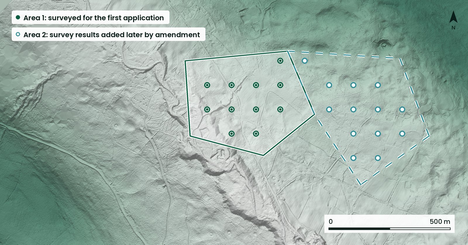
- NatureScot's licensing page says licence holders can add survey results over time by requesting a licence amendment.
- That means you can apply for a smaller area in the first year and submit more survey data later.
- For a non-peatland purpose, ground the interactive map classes as uncertain must be surveyed on a 100 m grid, with a walkover of non-peatland areas.
- Results must be typed into NatureScot's own template. Other formats are not accepted.
- Licence decisions rest with NatureScot.
This is a factual guide to phasing the survey side of a muirburn licence. It takes no position on muirburn itself. NatureScot facts are drawn from its licensing page and survey guidance, linked in the sources and checked on 18 November 2026. Check the live pages before you plan a survey.
Why phase the survey
NatureScot's licensing page says: "We understand it may take time to carry out peat depth surveys." The same page says licence holders can add survey results over time by requesting a licence amendment, so you can apply for a smaller area in the first year and submit more data later.
For an estate with a large area of uncertain ground, that turns one large survey into a sequence. The first application covers the ground you can survey and record now. Later amendments add the rest.
Deciding what goes in the first application
Three questions usually decide the first area:
- Which parts of the estate the burning plan needs first.
- Which of those parts the interactive map classes as uncertain, and so need a 100 m grid survey for a non-peatland purpose.
- How many field days the team can run within the season, which runs from 15 September to 31 March.
Areas mapped as non-peatland still need a walkover to confirm the absence of peat. Areas mapped as peatland only need surveying if you disagree with the classification and want a non-peatland licence for them. For a peatland purpose, NatureScot states that no survey is needed.
Planning the survey so each amendment is ready
- Survey in blocks you can submit. Plan each block as a complete area, with its grid points and walkover route, so the results can go in together.
- Use the template from the start. The interactive map provides coordinates (.gpx) and a survey template (.xls) for the area you specify. Results must be typed into that template.
- Record actual depths. Record the exact depth or the nearest 5 cm. A reading between 40 and 45 cm is rounded up to 45 cm. Readings must be actual depths, not "greater than" or "less than" 40 cm.
- Record the location. Give a 10-digit grid reference with its two-letter prefix for each probing point, and a distance if you had to move from the sampling point.
Where Vireo can help
Vireo's Probe Plan supports the survey. It does not replace it, and it plays no part in NatureScot's licence decision.
- Shows which parts of the estate the map reads as shallower and which as deeper, before survey (indicative).
- Helps plan which areas to survey and apply for first.
- Grid points laid out to the spacing the guidance sets, with field files for your surveyor.
- Results delivered in NatureScot's recording template, with a map.
On uncertain ground the NatureScot survey is still required. Vireo's map does not change what the guidance asks for. Vireo is not a regulator. Licence decisions rest with NatureScot. See the Probe Plan or read our muirburn licensing guide.
Questions and answers
Can I apply for part of my estate first?
Yes. NatureScot says licence holders can add survey results over time by requesting a licence amendment, so you can apply for a smaller area in the first year and submit more data later.
Do I need a survey for a peatland purpose?
NatureScot's licensing page states that you do not need to carry out a survey for a peatland purpose.
Can I send amendment results in my own spreadsheet?
No. Results must be typed into the template NatureScot provides. NatureScot cannot accept other formats.
Who decides the amendment?
NatureScot. Vireo is not a regulator.
Sources
- NatureScot: Muirburn licensing (read 18 November 2026)
- NatureScot: Guidance, peat depth survey for muirburn licensing (read 18 November 2026)
- NatureScot: Check your land for a muirburn application, interactive map (read 18 November 2026)
- legislation.gov.uk: Wildlife Management and Muirburn (Scotland) Act 2024, section 12; in force 15 September 2026 by SSI 2026/200
Contains public sector information licensed under the Open Government Licence v3.0. LiDAR: Scottish Government, Scottish Remote Sensing Portal.

Grid points and field files for your surveyor, and results in NatureScot's template.
See the Probe PlanTap real peat, river, habitat and ground motion data, read by the Vireo Neural Map.
Explore the live map