

Drone surveys and LiDAR mapping that end in an answer.
LiDAR, RGB photogrammetry, thermal, multispectral and hyperspectral drone surveys, satellite InSAR and ground radar, each commissioned to survey grade and read by the Vireo Neural Map into one record. You get the insight you asked for, not a folder of raw files.
Every enquiry is reviewed by the Vireo team. We reply within two working days.
See it read a real site. Tap live LiDAR terrain, habitat, river and ground motion data before you commission yours.
Explore the live map →Survey finder
Which drone survey does your site need?
Tell us what you need to know and how big the site is. The finder ranks the sensors that answer it, and shows what each one gives you.
1. What do you need to know? Choose any
2. How big is it?
Choose what you need to know to see your survey plan.
What each survey gives you
Nine sensors. Each one chosen for what it tells you.
Every survey is priced on request: specified to the decision it serves and quoted before anything flies.
LiDAR survey
Measures: Laser pulses that reach the ground through grass, heather and trees.
You get: Bare-earth terrain to centimetres, slope, drainage lines, earthworks and surface change between surveys.
Best for: Peat, slopes, flood flow paths, routes, heritage
RGB photogrammetry
Measures: Thousands of overlapping photographs stitched into one model.
You get: A centimetre orthophoto and 3D surface model: condition, volumes and change you can measure.
Best for: Site condition, earthworks, stockpiles, baselines
Thermal imaging
Measures: Surface temperature, by day or night.
You get: Where water seeps, springs rise, drains run and ground stays wet; hot spots after fire.
Best for: Drainage, seepage, wet flushes, fire
Multispectral imaging
Measures: Visible, red-edge and near-infrared bands.
You get: Vegetation health and habitat condition indices, mapped and repeatable season to season.
Best for: Habitat condition, BNG baselines, restoration
Hyperspectral imaging
Measures: Hundreds of narrow colour bands.
You get: Plant species, vegetation stress and surface materials a normal camera cannot separate.
Best for: Detailed habitat, peat condition, contamination screening
InSAR (satellite radar)
Measures: Radar from orbit, repeated for years.
You get: Ground moving up or down to about a millimetre a year, with no one on site.
Best for: Subsidence, slopes, coal tips, roads and rail
Ground penetrating radar (GPR)
Measures: Radar pulses reflected from layers below the surface.
You get: Continuous peat depth profiles, buried services and voids, without digging.
Best for: Peat depth, utilities, ground investigation
Magnetometry
Measures: Small changes in the earth's magnetic field.
You get: Buried ditches, kilns, walls and old workings mapped before a trench is opened.
Best for: Archaeology, mine entries, buried structures
Gas and emissions sensing
Measures: Methane and carbon dioxide in the air above the ground.
You get: Emission hotspots and gas flux mapped across a site, repeatable over time.
Best for: Mine and landfill gas, peatland emissions, pipelines
Why this matters
You want the answer, not the flight. Most survey data ends as files on a drive. Vireo specifies each capture to the decision, checks it reaches survey grade, and reads it with every other layer on one grid. The pack reads them together and answers the question.
What the evidence supports, and where to firm it up
Main findings, the key uncertainties, and the recommended next step, written for the person who has to sign off the budget.
Every layer on the same grid
Peat and soil, terrain and wetness, satellite condition, surface change and ground motion, water and catchment context, read on one 10 m grid, 1 m where LiDAR is held.
What you supplied, how it was used
Each file checked for format, coverage, date, licence and relevance, then placed on the same grid as the public sources. Not an attachment at the back.
Source, date, licence, limitation
Every figure carries where it came from, when, under what licence and with what evidence tier, so it can be explained to colleagues, clients, funders or regulators.
Where to look next, in order
The cells where the reads disagree, the gaps in your records, and a walkable plan for probing, monitoring or assessment, with the expected gain stated before anyone walks it.
Thirty minutes on the findings
One factual-correction round and one call to walk through the pack and agree the next step.
What a site check looks like
Your site, read by the Vireo Neural Map.
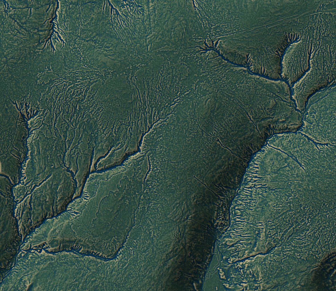
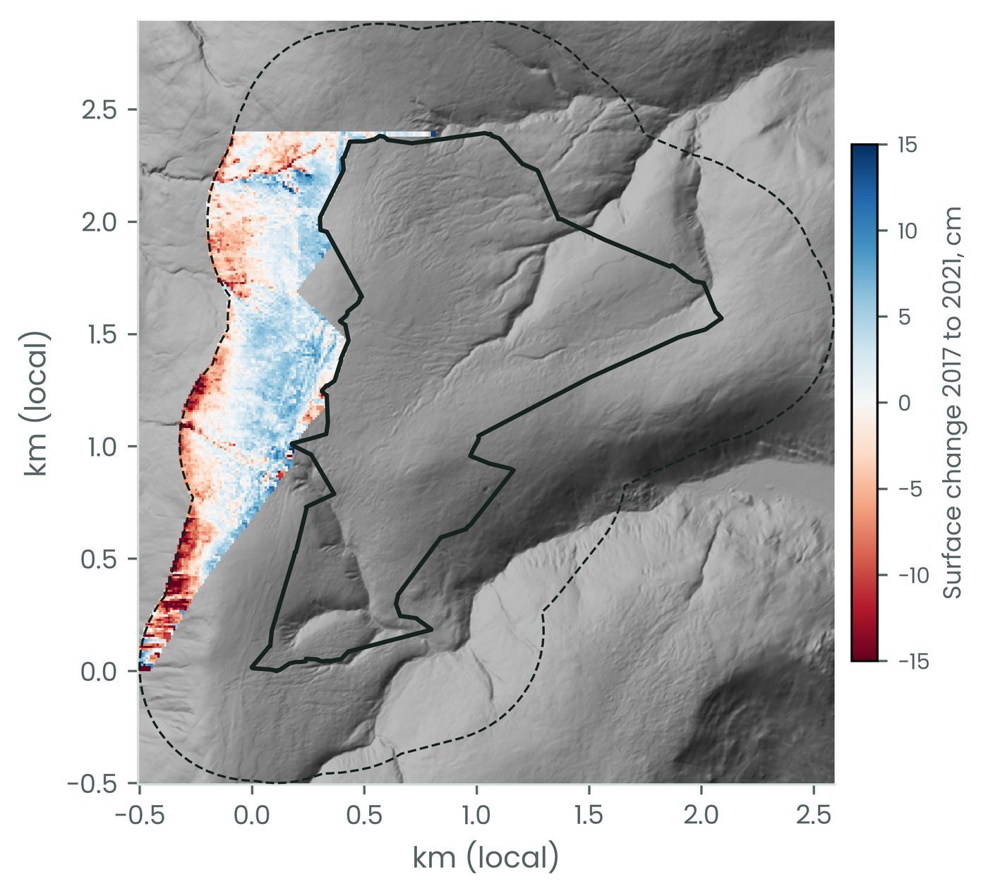
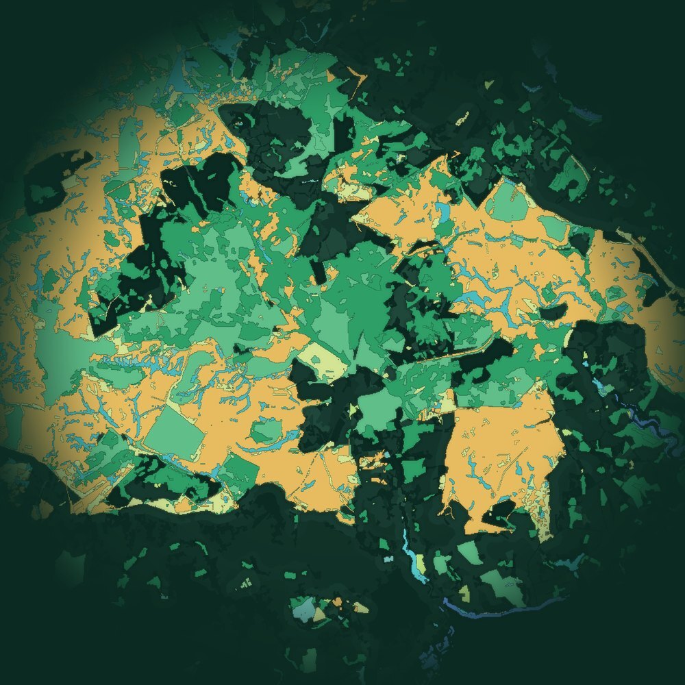
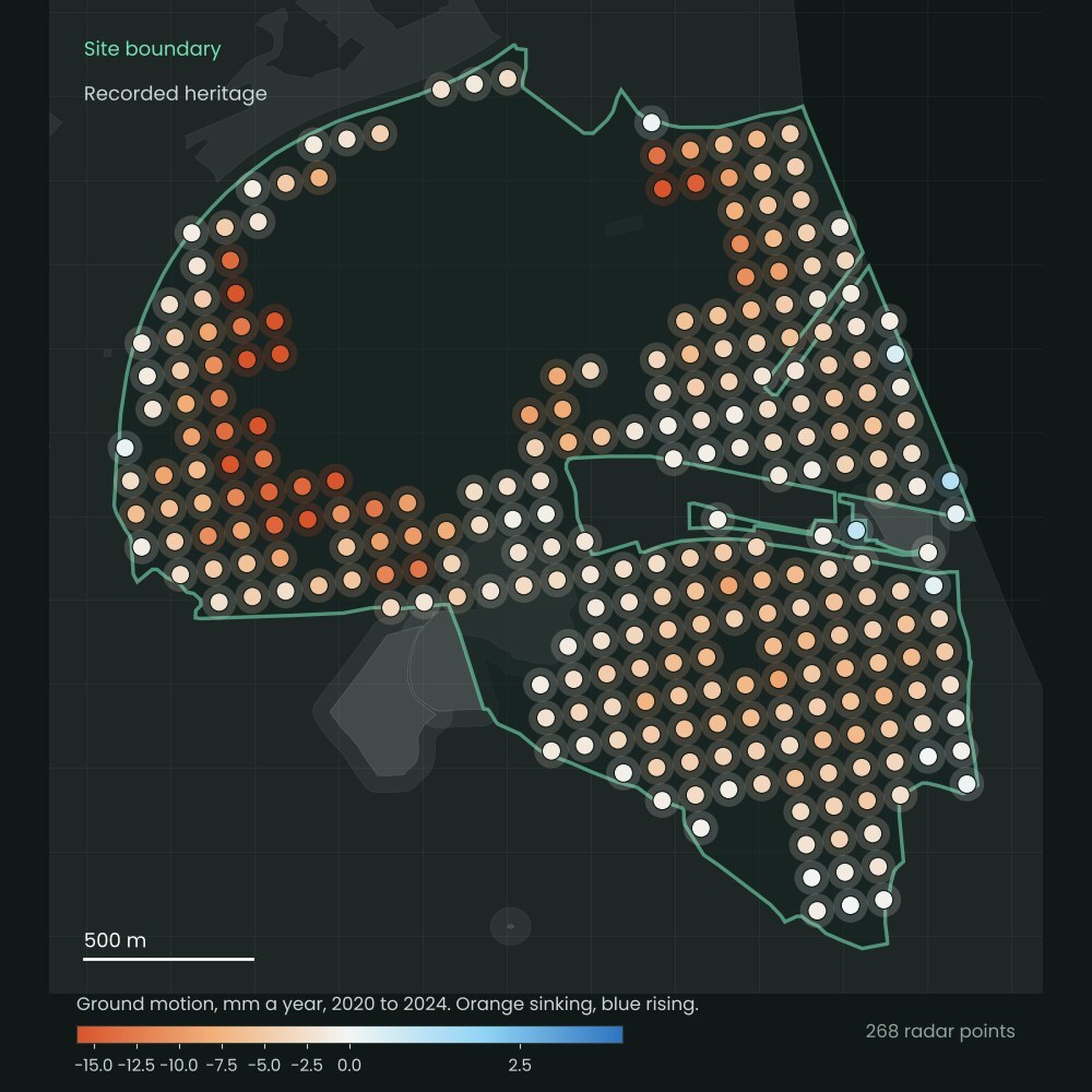
LiDAR terrain at 1 m, surface change between two LiDAR surveys, habitat classes read from imagery, and ground motion from satellite radar. Each one read into the same record, so every survey adds to the answer.
Proof behind every figure
Declared before it is scored. Scored once. Published either way.
Vireo sealed-test register, October 2026. See the blind-tested results
How it works
Send a boundary and your records. Get back a pack and a plan.
Send a boundary and your decision
One boundary, the decision you need to make, and a note of the records you hold. We confirm the site fits before you order.
We read your records with the public evidence
Up to ten of your files and the public evidence for that ground, placed on one grid and read together.
Pack in your hands
The pack, one factual-correction round and a 30-minute handover call on the findings and the next step.
Who it is for
Developers and consultancies
The surveys that change a layout or a consent, specified once and read with every other layer.
Landowners and estates
Habitat, peat and water mapped to a standard a buyer, funder or verifier will accept.
Asset and infrastructure owners
Slopes, routes and tips read again on a schedule, so change shows before it costs.
Launch offer
Ten sites at the launch price.
The pack shows which surveys will pay before you commission any of them.
Excluding VAT where applicable. The standard Site Evidence Pack price is £9,600 a site. The first three launch sites are delivered and reviewed before the remaining seven places open.
You pay £3,600 for the pack. You also receive a £3,600 credit towards a Vireo Site Assessment (£25,000), the calibrated read with sealed checks on your own probes, valid for 12 months from delivery of the pack.
Questions
Prices exclude VAT where applicable. Example outputs are from one anonymised upland site and show the format of your pack.
Can a drone survey replace a topographical survey?
For open ground, a LiDAR or photogrammetry drone survey produces the terrain model and contours a topographical survey delivers, across a whole site in one flight. Hard detail such as building lines, manhole levels and boundaries may still need a surveyor on the ground, so Vireo specifies the mix against the decision.
What is a GPR survey?
Ground penetrating radar sends radio pulses into the ground and records what reflects back, revealing buried services, voids, foundations, archaeology and the depth of soft layers such as peat. It is run on foot, by vehicle or from a drone, and Vireo reads the result with the terrain and your records on one grid.
What does a drone survey cost?
Every survey is priced on request, because the cost depends on the sensor, the area and the standard the result has to meet. Vireo specifies each survey against the decision it serves, so you pay only for data that changes the answer, and you have a fixed quote before anything flies.
LiDAR or photogrammetry: which do I need?
Photogrammetry gives a sharp picture and surface model of everything visible. LiDAR reaches the ground through grass, heather and trees, so it is the choice for terrain, peat, slopes and drainage. Many sites need both, captured on the same flight.
What is hyperspectral imaging used for?
Hundreds of narrow colour bands separate plant species, vegetation stress and surface materials that a normal camera cannot tell apart. It sharpens habitat condition, restoration monitoring and contamination screening.
What is InSAR?
Satellite radar that measures ground moving up or down to about a millimetre a year, from archives that go back years. It reads subsidence, slopes, tips and routes with no one on site.
Who flies the survey?
Vireo commissions the best-placed licensed operator and sensor for each job, sets the capture standard, checks every dataset before it is accepted, and reads it into the Vireo Neural Map. You get results, not raw files.
Which survey does my site need?
Use the survey finder on this page, or send the site and the decision. We recommend the sensors that change the answer, and tell you which ones you can skip.