

Offshore wind and marine monitoring, with a record back to 2017.
Marine environmental monitoring for offshore wind and the coast: seabed and scour registers, pre-construction baselines, sediment plume and turbidity records, and water clarity over seagrass and marine conservation zones. Every clear satellite pass since 2017, beside the open seabed surveys, read before your vessel sails.
Every enquiry is reviewed by the Vireo team. We reply within two working days.
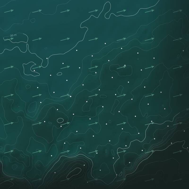
Turbines · Seabed depth · Tidal stream · Water clarity. One record per structure.
One farm, every structure
Seabed survey, scour and water clarity, read structure by structure.
The open multibeam bathymetric survey, the tidal stream and every clear satellite pass placed on one record for each foundation and cable route. Shown: an anonymised UK farm, each turbine located from the imagery, on the measured seabed with depth contours and the axis of the tidal stream.
- 100+Structures found from orbitEvery turbine and substation in a UK farm located from the imagery itself, in every clear scene, and tracked.
- 9Years of passes before your worksWater clarity in rings round each structure on every clear pass since 2017, so the baseline already exists.
- 2 mSeabed detail at each foundationOpen multibeam surveys read at every turbine: bare bed, armour or an early pit, ranked for your next scour survey.
From consent to decommissioning
Offshore wind evidence for every marine and coastal decision.
Pre-construction baseline
Water clarity over the array, the export cable corridor and the neighbouring marine protected areas, every clear pass from 2017 to final investment decision. The baseline exists before a vessel is booked.
Construction plume record
Each clear pass during works read against that baseline: where the sediment plume went, how far and for how long, aligned to your monitoring plan and marine licence conditions.
Scour and seabed register
Seabed state at every foundation from open multibeam surveys and your own, ranking the turbines that look as scoured ones did before their pits formed, so scour protection and surveys go where they matter.
Nature-inclusive design and reefs
Reef, rock-armoured and bare foundations read on the same rings and tidal wake in each survey year, beside your ecology campaigns, under rules fixed before the data exist.
Marine conservation zones
A water clarity record over marine conservation zones and other designated sites through the sensitive season, built as your own record for consent discharge and stakeholders.
Seagrass, saltmarsh and blue carbon
Coastal water clarity, light to the meadow and intertidal change, with the weather separated out, so a restoration outcome can be told apart from the wind.
What the engine reads
Marine environmental monitoring, checked before it is trusted.
Two real reads, anonymised: a UK offshore wind farm of more than 100 structures, and a south-coast bay. The engine is checked on something it must see, sets its detection limit before anyone asks, and separates weather from cause.
Proof behind every figure
Every number carries its tier. Outcomes are declared before they are scored.
Vireo marine reads, October and November 2026. Explored: Vireo analysis, not yet a sealed test. See how sealed tests work
A bay, read from orbit
Coastal water clarity monitoring, pass by pass.
The same south-coast bay on three clear Sentinel-2 passes. Lockdown, day three: murky water and no ships. Ten days later the wind eased and the water cleared. A year on, four lay-up cruise ships at anchor and the water normal. The engine counts every ship, reads every pass and tests every cause, so the weather is never mistaken for an impact.
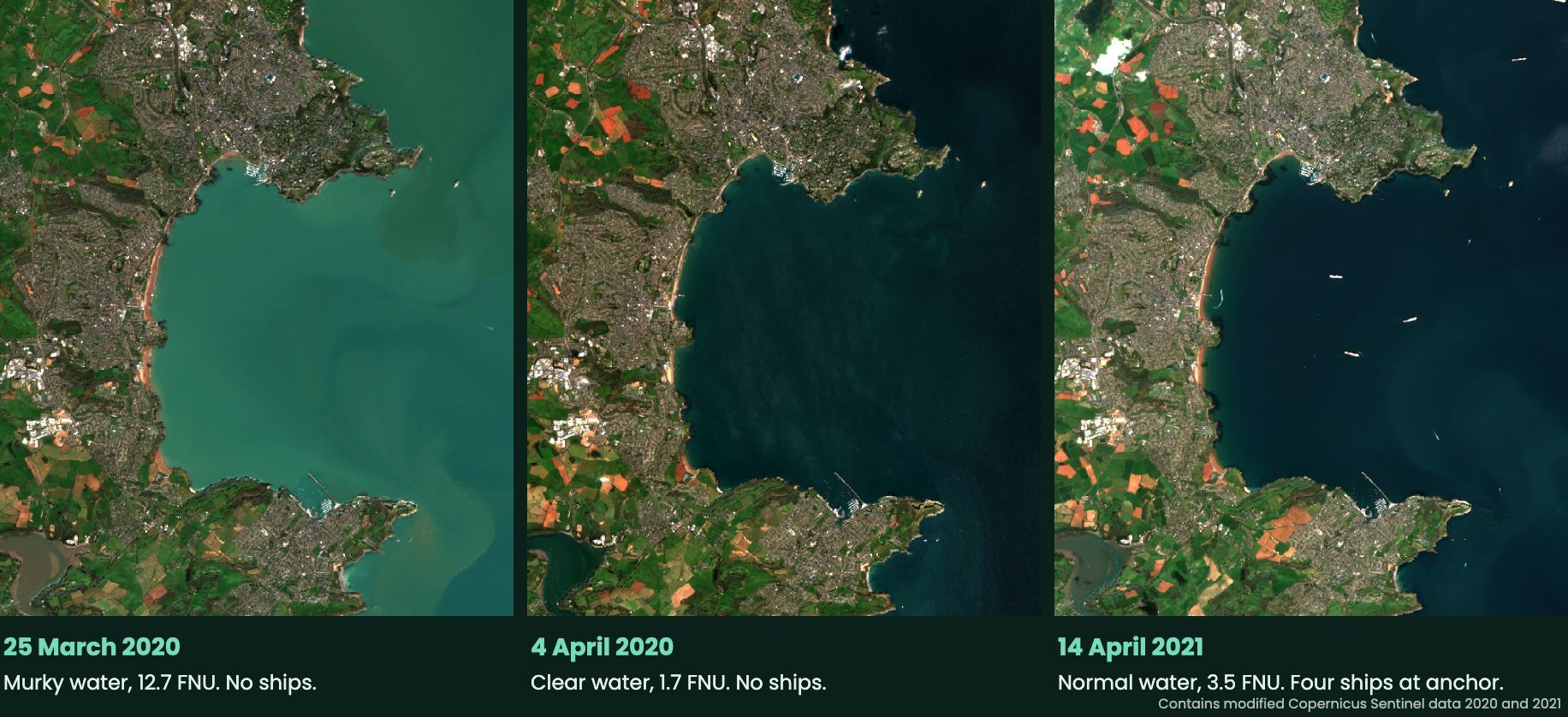
Contains modified Copernicus Sentinel data 2020 and 2021. Turbidity in FNU from the red band, Vireo water engine. Evidence tier: Explored.
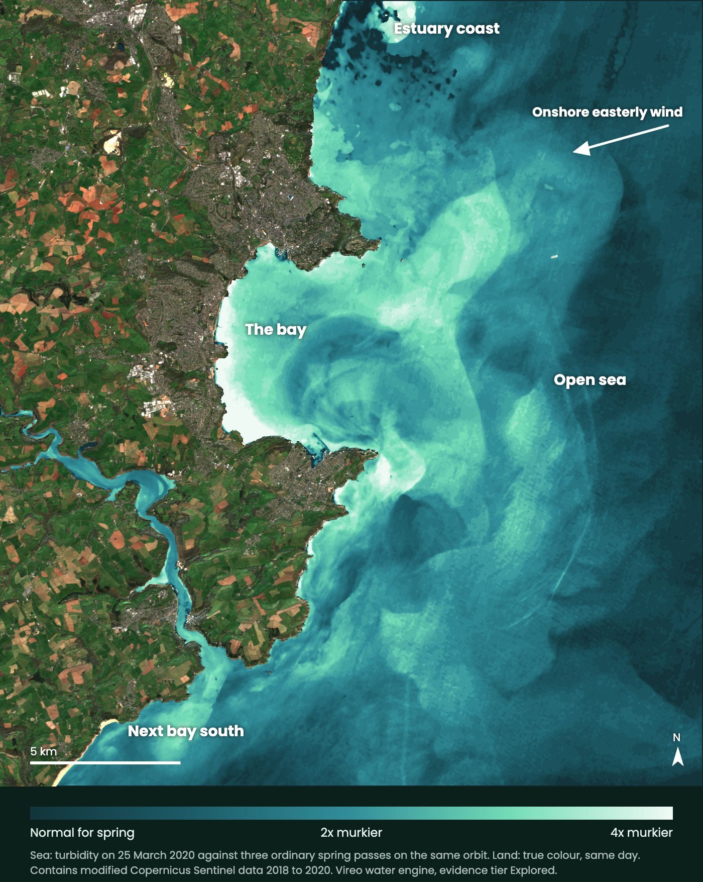
Weather, not ships
The whole coast went murky, open sea too.
On the murkiest day of that spring, the engine compared every 10 m of sea with ordinary spring passes from the same satellite orbit. The bay, the next bay south and the open sea all ran two to three times murkier, with sediment swirling in eddies driven by an onshore easterly wind.
A discharge shows as one plume from one place. This was a coast-wide weather signal, and the engine separates it from any local impact before anyone draws a conclusion.
How it works
Send an array, a cable route or a coastline. Get back a record and a plan.
Send the boundary and the question
An array, an export cable corridor, a bay or a protected site, the decision it serves, and the surveys you already hold.
We build the record
Every clear pass since 2017, the open seabed surveys, tidal currents and designated sites, with your own surveys placed on the same record.
Record, rules and next step
The record with its detection limits, a survey and monitoring plan, and, where an outcome must be proved, rules written down before the data arrive.
Who it is for
Offshore wind developers and operators
Baselines, plume records and scour registers mapped to consent conditions and survey calendars.
Marine consultancies and surveyors
A record and survey priorities before the vessel sails, and a home for your results after.
Ports, coastal authorities and restoration groups
Water clarity over seagrass, saltmarsh and marine conservation zones, with the weather separated out.
Start with one structure or one bay
A first read, scoped to your question.
The record briefs, and sits alongside, the marine surveys and ecology campaigns your consent requires.
Each read is scoped to one array, cable route or stretch of coast and the decision it serves. We confirm the satellite record and the open surveys cover your site before anything is agreed.
Questions
Examples are anonymised Vireo reads of a UK offshore wind farm and a south-coast bay, evidence tier Explored. Satellites read surface water in clear weather; seabed and in-water instruments remain the record for the bed and water column.
What does marine environmental monitoring cover for offshore wind?
Offshore wind consents ask for evidence before, during and after construction: seabed and benthic baselines, sediment plume and turbidity during works, scour around foundations and cables, and effects on designated sites. Vireo reads water clarity on every clear Sentinel-2 pass since 2017, places it beside open seabed surveys and tidal models, and builds a record your marine surveys and ecology campaigns slot into.
Can satellites monitor turbidity and sediment plumes?
Yes, in clear weather. Optical satellites such as Sentinel-2 measure how much light the surface water scatters, which tracks suspended sediment. A plume that rises on a clear pass is recorded, mapped and compared with the baseline. Satellites read the surface, so seabed and in-water instruments remain the record for the bed and the water column; Vireo places both in one record.
How is scour monitored around offshore wind turbines?
Scour is measured by multibeam bathymetric surveys of the seabed around each foundation. Vireo reads the open multibeam surveys already published for UK waters, structure by structure, and ranks the foundations whose seabed looks most like those that later developed scour pits, so your next survey and any scour protection go where they matter.
What is a pre-construction baseline, and why start in 2017?
A baseline is the record of conditions before works begin, against which construction and operation are judged. The Sentinel-2 archive runs back to 2017, so a water clarity baseline for an array, its export cable corridor and nearby designated sites can be built today for every clear pass of the last nine years, before any vessel is mobilised.
Do you cover seagrass, saltmarsh and blue carbon?
Yes. The same engine reads coastal water clarity, the light that reaches seagrass meadows, and change in intertidal habitats such as saltmarsh. In one south-coast bay it showed that a spring spike in murky water came from onshore wind stirring the bed, not from anchored ships, which matters for any restoration that must be told apart from the weather.
Do you replace marine surveys?
No. Vireo sets the record and the questions before the vessel sails, and places your multibeam, grab, ROV and eDNA results on the same record afterwards. Every figure carries its source, licence and evidence tier, and any claimed outcome is tested under rules fixed before the data exist.